Friday, March 15, 2013

Rancho Chato

Thursday we investigated several reported caves on Rancho Chato, situated on the west slopes of Santa Cruz.  Our team of 9 once again piled in to 2 truck taxis (designed to carry 3 passengers each) and made the 20 min. drive out to the ranch.  The previous day's rains were evident in this area as washouts on the gravel roads, and pools of water where usually dry.

We spoke with the caretaker of the ranch and discovered that there were several other caves on the property in addition to the ones that we already had information for.  We divided in to 3 survey / exploration teams and continued down the ranch road.

On the road - Rancho Chato


We dropped Bob, Eli and Scott off to check out a cave downslope of the main cave on the property.  The owner did not have any information on the cave, but thought that it continued for some distance.  They were able to survey 389m (including a 5m pit) before being stopped by a terminal blockage in the cave.

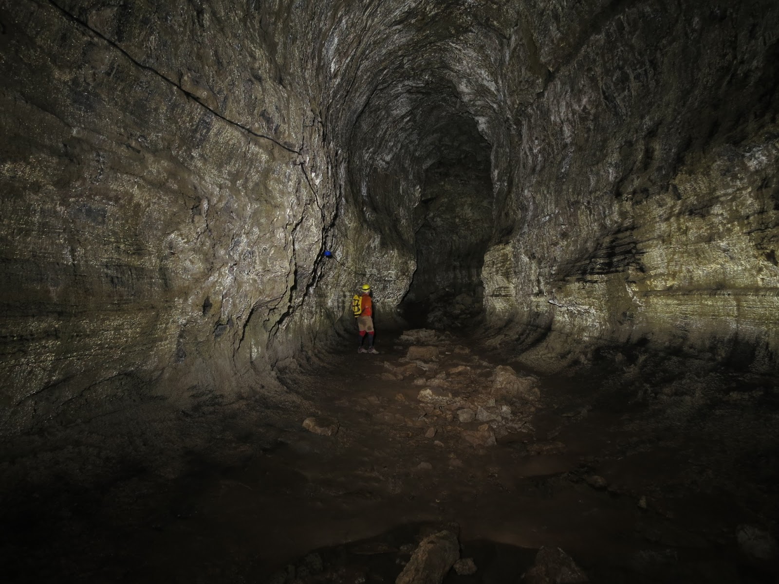
The remainder of the teams continued to the main cave "Tuneles de los Piratas",  The entrance to the cave is in a collapse feature that has caves on both sides.  This is quite common with lava tubes. Chris, Geoff and Rick T.  started surveying down flow from the entrance, surveying 216m for the day.  This section of the tube was characterized by a short (but very steep) climbdown and somewhat muddy sections of cave.

My team of Theo and Rick H. started the survey of the main cave, half of which is operated as a tourist cave.  This section of the system is a little unusual  as it has two parallel passages for the entire length of the cave.  The cave had some of the largest passage that we have encountered so far.  We concentrated on survey yesterday, so I did not get very many pictures.  Hope to be able to finish the survey Friday and also get some better photos.

Tuneles de los Piratas


Although we are in Galapagos for cave exploration, sometimes being in the right place at the right time has its benefits.  Here is a photo of rays swimming in the harbor last night.

rays swimming at night

Thursday, March 14, 2013

Sometimes it rains in the tropics

Wednesday was rainy and dreary day on Santa Cruz.  While it rarely rains at sea level in the Galapagos, it is not uncommon for elevations higher on the volcanoes to see daily rain.  Usually March is the dry season in the islands, but this year the locals say it has rained quite frequently.  It is impossible to stay dry, despite best efforts.  The ground is saturated and the vegetation is thick.  Just brushing against the large leaves of a banana tree can soak a pair of pants.  The understory of the jungle is thick with water loving plants and everyone gives up attempting to stay dry at some point during the day.

heavy rain on Santa Cruz.  Note the giant tortoise beyond the sign.


We investigated 4 caves on Rancho Primicias today.  One of the tubes is operated as a tourist cave, complete with lighting.  Bob, Rick H. and Elizabeth surveyed this tube to 420m.  Chris (aka Batgirl), Geoff and Rick T. surveyed the down flow continuation of the tube another 203m before reaching a collapse that was impassible.  These types of tube segments seem to be common on Santa Cruz.

While the above teams were surveying, Theo and I returned to Pto Ayora to meet with PNG officials and try to work through the paperwork necessary to continue our permit to work in the national park areas of Galapagos.  This is a lengthy process with many waiting periods.  We made little progress on this day and returned to the group to help in any way we could.

The rains dampened the enthusiasm for thrashing through the jungle and locating new caves with the local guide.  Still, Chris, Rick T., Geoff and I headed out in a steady rain to locate two new caves.  We made a 1km hike, located one nice tube with a walk-in entrance, and a second cave with a 7m skylight drop in to a short tube segment.  Chris droppped the pit and discovered that there was a small entrance to the cave nearby that did not require ropework.  We got a GPS location and made the return hike in the rain.  The total time for this little side trip was less than one hour.

Tomorrow we are checking out a braided lava tube reported by locals to be over 1km long. 

Tuesday, March 12, 2013

Tuesday 3.12.2013


Tuesday 3.12.2013

Today we returned to the Gallardo ranch to clean up leads in the area.  The first team of Bob, Scott and Geoff headed back in to the down flow section of Cueva Gallardo to finish off this cave and photograph the lava formation area.  They were able to add 580m before being stopped at a lava seal (lava just seals off the passage with no continuation).

The second team of Chris, Elizabeth and Rick H. went to investigate a tube segment that can only be accessed via a 6m drop through a skylight.  They took a short rope and their vertical gear along on the 1km hike to the cave.  After rappelling in via the skylight, they observed that the drop was free climbable.  The team surveyed up flow to a ramp entrance, and down flow to a lava seal.  Overall the team surveyed 410m in this nice tube segment.

Rick Toomey looks toward Theo Toulkerdis on a lava ramp
The final team of Aaron, Rick T. and Theo began the survey of Cueva Soyla, a new cave that the owner had mentioned to us a couple of days earlier.  The entrance to the cave was located in the back of a banana tree field that had blackberries and cherry tomato plants covering the ground.  The entrance to the cave was covered by blackberry vines, but once we cleared them, we discovered a nice walk in entrance.

The team set six stations before coming to the top of a short lava fall/ramp, where the floor dropped away quickly and was joined by a lower tube coming in to the passage. 


We continued our survey through beautifully colored passages, with dimensions ranging from just a couple of meters wide and tall, to grand passages that amaze at each turn.


R. Toomey and T. Toulkeridis explore Cueva Soyla


The cave finally ended on us after surveying 1038m in 7hrs.  The last three stations were on a very muddy floor with little room to move around.  The cave may continue, but it would require a significant digging effort in less than desirable conditions.


The cave continued on for 3 more unpleasant stations.


Overall it was a great day for the expedition, with the 3 teams netting a total of 2028m of survey.  The overall trend of the lava tubes is very interesting, and may prompt more surface investigation for tube continuations. 

The total survey for the first three days of the expedition stands at 3.7km.

Senior Gallardo's cave


The internet was down last night here on the islands, so I was not able to post to the blog.  Yesterday (Monday), we sent two survey teams back to Cueva Gallardo to continue the survey there, while Theo and I stayed behind in town to speak with the Galapagos National Park regarding our permit to survey caves on Park property.  Unfortunately the person we needed to speak with was out (on the mainland) and will not return until Tuesday afternoon.  We will try again!  Afterwards, we returned to grab our caving gear and head out to the cave and meet the other teams.  Upon arrival at the cave, Theo and I had the pleasure of meeting Senior Gallardo.  Gallardo discovered the cave we are surveying in the 1940s after coming to the islands to teach school.  He has been here ever since, and gets around amazingly well for a 96 year old gentleman.  I am sure that he has done his share of cave exploring in his day.

The team with senior Gallardo


Everyone was at the cave and surveying by 11am.  We split in to three teams and pushed the cave down the flow to another entrance.  As previously mentioned, the down flow section of the cave is closed to tourists.   The passage is mostly elliptical, with short sections of rock and breakdown on occasion.  the lava is very unforgiving, and the slightest slip can lead to badly bruised areas and/or severe cuts.  Adding to the scene, the rocks can be very unstable at times, easily leading to turned ankles and falls.  The expedition carries a large first aid pack at all times.

Some of the passages today were exceptional, with a favorite being the oddly alternating wall patterns that resemble zebra stripes.

Rick T. and Theo work to photograph an unusual spider


Other passages were quite large, including a near oxbow, not dissimilar to those found on rivers.  One major challenge in photographing lava tubes are their dark colors that seem to soak up all available light.  These photos were taken at 15sec. exposure, so the people in the frame have to stand very still. 

oxbow area of Cueva Gallardo


At the end of the day we headed back to camp, and Cueva Galalrdo was over 1700m of surveyed passage.  Tuesday promises to be a good day, so stay tuned…..


Sunday, March 10, 2013

Caving Begins


I was outsmarted by my smart phone.  Last night we made arrangements to eat breakfast at 7am and get an early start.  Unfortunately, last night was also time to "spring forward" for daylight savings time.  Since Galapagos sits on the equator, there is not really any benefit to daylight savings time, so they maintain standard time year round.  My android phone does not.....  The short of it is that when you set an alarm for 6:30 on a smart phone that usually finds itself in the midwest USA, it does not adjust well to the tropics.  On the upside, I was up before sunrise and had time to stroll down to the harbor and snap a few photos of sunrise.

Galapagos sunrise


We began our cave explorations today.  Our first objective was to check out a cave that has been operated as a commercial cave for several years.  It is a large tube segment that the owners have installed a simple fluorescent lighting system for the visitors.  As is the case in many cave systems, this small segment of about 800m is well known, but the continuation of the tube (both upslope and downslope) are not well known to locals.  We offered to survey the known part of the cave, and also to document the non-tourist parts of the cave.  There are currently 2250m of known cave, but we hope to be able to expand this greatly during our trip.

We broke in to three survey teams, with each team having two people.  The goal was to finish the tour trail section of the cave and begin work on the non-tourist portion.  Bob Osburn and Geoff Hoese headed to the skylight in the rear of the tourist part, while Chris Omura and Scott Linn headed in to the non-tourist section.  My team included Rick Haley and we began our survey at the main entrance of "Tunel Del Amor".

The cave was a typical lava tube with mostly smooth floors and occasional breakdown (rock piles).  IN some areas it was possible to see the lines on the walls where past lava flows had used the cave as a conduit.  The lava tubes on Santa Cruz island are quite old (+100,000 years), so there is no real danger of the tube being filled with lava today.  There is ample evidence to suggest that this particular tube has been a main lava conduit for the volcano during multiple events.  This phenomena is observable when the tube takes on a "stacked" form that results in a tall horseshoe shaped passage.

Cueva Gallardo, Santa Cruz island

Overall, the surveying of these tubes is straightforward.  The two teams working in the tourist area of the cave were able to complete the 800m of mapping in about five hours.  The team working in the non-tourist section of the cave was able to survey about 114m, for a Day 1 total of 914m.  Just shy of a kilometer on the first day is not a bad way to start the trip.


Saturday, March 9, 2013

Taking steps to protect a unique environment


The Galapagos is well known as a special place.   Paramount to maintaining this condition is the close control of items being brought to the islands.  All persons boarding flights to Galapagos must pass through the SICGAL control.  All bags are x-rayed for outside food and plants that are prohibited to bring from the outside.

Friday, March 8, 2013

Introductions

It has been pointed out that I have already committed a blogosphere faux paux by not properly introducing myself here.  We are currently awaiting our next flight here in Miami, so I suppose this is as good of time as any to say a few words.

My name is Aaron Addison and I am the Director of GIS & Data Services at Washington University in St. Louis.  My team provides supporting technology and services to the entire WUSTL community.   Recently, our group became a part of University Libraries, with offices in Olin Library on the Danforth Campus.  In addition to leading the above team, I also teach GIS courses in the Brown School and University College.  Within UCollege, I also oversee the GIS Certificate program.  It is a very exciting time to be a part of the WUSTL fabric!

My passion for Geographic Information Systems (GIS) began early in life with a fascination for maps.  I was fortunate to travel as I was growing up, giving me a sense of place and space.   This interest continued to grow as I entered my undergraduate years and eventually led me to GIS.  I spent about 15 years working in the private sector on a variety of projects, mostly related to engineering and architecture.  I completed my graduate degree in Geographic Information Science just prior to my appointment at the university.

How about the caving you ask?  Well, you can blame all that on a library book.  When I was in high school, I went to the local university library with a friend on a whim.  He was doing some research and I was bored.  While roaming the stacks, I happened across some books on caving.  I have been at it ever since.

Caving has been the doorway to many adventures.  From exploring the caves in Illinois and Missouri, to participating in National Geographic sponsored expeditions in remote areas of Laos.  Currently my major projects are in the Yucatan peninsula of Mexico, and of course in Galapagos.  The Galapagos project is actually much bigger and includes all of Ecuador, but that will have to wait for a different post.  We are boarding...next stop Guayaquil, Ecuador.